Responsible partners:
Geomorphometric models perform a number of operations on Digital Elevation Maps (DEMs) in order to calculate factors like hydrological flow directions and water pooling, and produce the relevant maps. Such models are critical for optimising various agricultural processes, as they can be exploited for building precise crop growth models based on fine-grained water availability, forecasting soil suitability and erosion, and optimising fertiliser usage. Pilot #4 is about creating high-precision, multi-factor models using very large data volumes. Antonis Koukourikos from Scio gave us some insights into the current status of the research.
Can you please summarize what pilot #4 is about?
The current implementation of the groundwater estimation and management service operates over relatively small land areas and uses the single-threaded implementation of the Open-geomorphometry toolset. While the service provides adequately accurate results, it can be improved by, firstly, not relying on coarse or artificially produced Digital Elevation Maps and instead incorporate modules for producing such maps from openly available EO data. Secondly, given the existence of sufficient infrastructural support, it can improve its responsiveness via an intricate parallelisation design, which will allow the optimisation of individual operations, as well as the communication between the different steps of the entire workflow.
Thus, the main objectives of the relevant REGALE pilot are:
- To make full use of multi-threaded parallelised environments for executing the various computational tasks entailed in the service.
- To efficiently balance persistent and in-memory data storage by designing a more refined workflow that covers the distinct computation steps of the estimation service.
- To optimize the execution of the service’s workflow, using the workflow management services provided by REGALE and RYAX in particular.
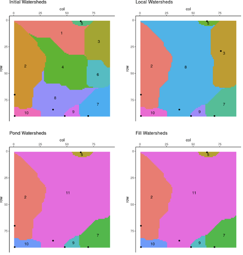
Figure 1: Output of the open geomorphometry tool
What is the research field?
The research field is Computational Fluid Dynamics and Geospatial analysis. SCiO is responsible for optimising and configuring the source code of the open geomorphometry tool to be ready for deployment in scalable, high-performance infrastructures. RYAX will provide its platform and in collaboration with SCiO, set up the optimal execution environment for the overall tool.
What are the main challenges in your pilot?
The barriers to provide high-precision groundwater estimation services are the required computational and storage resources due to the size of the data and the complexity of the models. High-performance data analytics infrastructures, such as the ones proposed by REGALE, are necessary to lift these barriers and offer services that would enhance agricultural operations, environmental research and policy making.
What do you expect from REGALE?
Our expectations can be summarized in three main points:
- Increase the capability of the system with respect to the analysis of digital elevation maps that can be feasibly used as input to the described models
- Increase coverage, that is the land area that can be covered in acceptable computation times
- Optimise workflow execution in terms of data processing, intermediate result production and transferring and inter-process communication in the context of the service.